Thank you for supporting this site ❤️
Make a donation
Make a donation
Gear up for your next adventure:
As an Amazon Associate, this site earns from qualifying purchases at no extra cost to you.
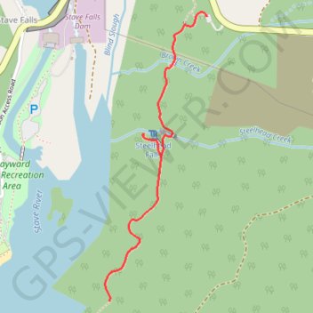
Hayward Lake - Steelhead Falls
- Distance: 3.6 Km
- Elevation gain: 158 m
- Maximum elevation: 143 m
- Elevation loss: 159 m
- Minimum elevation: 80 m
Interactive trail map
Thank you for supporting this site ❤️
Make a donation
Make a donation
Gear up for your next adventure:
As an Amazon Associate, this site earns from qualifying purchases at no extra cost to you.
Trail profile
- Distance: 3.6 Km
- Elevation gain: 158 m
- Maximum elevation: 143 m
- Elevation loss: 159 m
- Minimum elevation: 80 m
Thank you for supporting this site ❤️
Make a donation
Make a donation
Gear up for your next adventure:
As an Amazon Associate, this site earns from qualifying purchases at no extra cost to you.
About this trail
Name: Hayward Lake - Steelhead Falls trail, distance, elevation, map, profile, GPS track
Coordinates: 49.21917 -122.35299 49.22971 -122.34730
Thank you for supporting this site ❤️
Make a donation
Make a donation
Gear up for your next adventure:
As an Amazon Associate, this site earns from qualifying purchases at no extra cost to you.
Other hiking, mountain biking, running and outdoor activity trails
Click on a trail to view its statistics, map and profile.