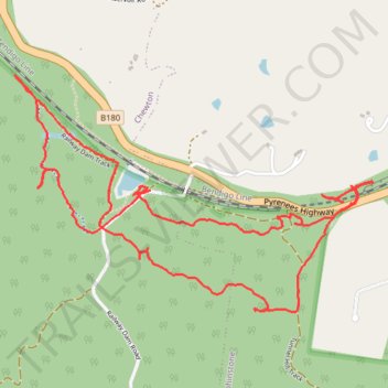
Fryers Ridge State Forest - Railway Dam loop walk
- Distance: 6.6 Km
- Elevation gain: 145 m
- Maximum elevation: 489 m
- Elevation loss: 146 m
- Minimum elevation: 398 m
- Moving time: 1 h 33 m
- Moving speed: 4.3 Km/h
- Maximum speed: 9.4 Km/h
- Total time: 1 h 39 m
- Global speed: 4.0 Km/h
Interactive trail map
Trail profile
- Distance: 6.6 Km
- Elevation gain: 145 m
- Maximum elevation: 489 m
- Elevation loss: 146 m
- Minimum elevation: 398 m
- Moving time: 1 h 33 m
- Moving speed: 4.3 Km/h
- Maximum speed: 9.4 Km/h
- Total time: 1 h 39 m
- Global speed: 4.0 Km/h
About this trail
Name: Fryers Ridge State Forest - Railway Dam loop walk trail, distance, elevation, map, profile, GPS track
Coordinates: -37.10979 144.29123 -37.10005 144.30971
Topography: Victoria topographic map, elevation, terrain