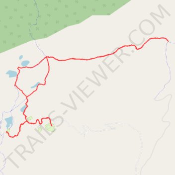
Barker Lakes Complex
- Distance: 15.4 Km
- Elevation gain: 356 m
- Maximum elevation: 2,953 m
- Elevation loss: 357 m
- Minimum elevation: 2,837 m
- Moving time: 2 h 26 m
- Moving speed: 6.3 Km/h
- Maximum speed: 40.8 Km/h
- Total time: 4 h 58 m
- Global speed: 3.1 Km/h
Interactive trail map
Trail profile
- Distance: 15.4 Km
- Elevation gain: 356 m
- Maximum elevation: 2,953 m
- Elevation loss: 357 m
- Minimum elevation: 2,837 m
- Moving time: 2 h 26 m
- Moving speed: 6.3 Km/h
- Maximum speed: 40.8 Km/h
- Total time: 4 h 58 m
- Global speed: 3.1 Km/h
About this trail
Name: Barker Lakes Complex trail, distance, elevation, map, profile, GPS track
Start: Site 12, Main Loop, Garfield County, Utah, United States (37.92042 -111.81587)
End: Site 12, Main Loop, Garfield County, Utah, United States (37.92038 -111.81586)
Coordinates: 37.91796 -111.82857 37.93993 -111.78320