Thank you for supporting this site ❤️
Make a donation
Make a donation
Gear up for your next adventure:
⌚Altimeter Barometer Watches - Outdoor watches with built-in sensors to track altitude changes and weather shifts
As an Amazon Associate, this site earns from qualifying purchases at no extra cost to you.
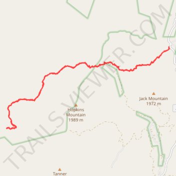
Hells Hole Trail to Boyer Trail
- Distance: 20.0 Km
- Elevation gain: 861 m
- Maximum elevation: 1,700 m
- Elevation loss: 859 m
- Minimum elevation: 1,501 m
- Moving time: 6 h 46 m
- Moving speed: 2.9 Km/h
- Maximum speed: 5.5 Km/h
- Total time: 8 h 37 m
- Global speed: 2.3 Km/h
Interactive trail map
Thank you for supporting this site ❤️
Make a donation
Make a donation
Gear up for your next adventure:
As an Amazon Associate, this site earns from qualifying purchases at no extra cost to you.
Trail profile
- Distance: 20.0 Km
- Elevation gain: 861 m
- Maximum elevation: 1,700 m
- Elevation loss: 859 m
- Minimum elevation: 1,501 m
- Moving time: 6 h 46 m
- Moving speed: 2.9 Km/h
- Maximum speed: 5.5 Km/h
- Total time: 8 h 37 m
- Global speed: 2.3 Km/h
Thank you for supporting this site ❤️
Make a donation
Make a donation
Gear up for your next adventure:
As an Amazon Associate, this site earns from qualifying purchases at no extra cost to you.
About this trail
Name: Hells Hole Trail to Boyer Trail trail, distance, elevation, map, profile, GPS track
Start: Hells Hole Trail 284, Gila County, Arizona, United States (33.87119 -110.97513)
End: Hells Hole Trail 284, Gila County, Arizona, United States (33.87107 -110.97515)
Coordinates: 33.84450 -111.04019 33.87184 -110.97511
Thank you for supporting this site ❤️
Make a donation
Make a donation
Gear up for your next adventure:
As an Amazon Associate, this site earns from qualifying purchases at no extra cost to you.