Thank you for supporting this site ❤️
Make a donation
Make a donation
Gear up for your next adventure:
As an Amazon Associate, this site earns from qualifying purchases at no extra cost to you.
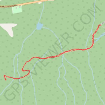
Bella Coola - Snooka trail - west
Bella coola, bc
- Distance: 5.2 Km
- Elevation gain: 226 m
- Maximum elevation: 212 m
- Elevation loss: 227 m
- Minimum elevation: 28 m
- Moving time: 1 h 42 m
- Moving speed: 3.0 Km/h
- Maximum speed: 6.1 Km/h
- Total time: 1 h 52 m
- Global speed: 2.8 Km/h
Interactive trail map
Thank you for supporting this site ❤️
Make a donation
Make a donation
Gear up for your next adventure:
As an Amazon Associate, this site earns from qualifying purchases at no extra cost to you.
Trail profile
- Distance: 5.2 Km
- Elevation gain: 226 m
- Maximum elevation: 212 m
- Elevation loss: 227 m
- Minimum elevation: 28 m
- Moving time: 1 h 42 m
- Moving speed: 3.0 Km/h
- Maximum speed: 6.1 Km/h
- Total time: 1 h 52 m
- Global speed: 2.8 Km/h
Thank you for supporting this site ❤️
Make a donation
Make a donation
Gear up for your next adventure:
As an Amazon Associate, this site earns from qualifying purchases at no extra cost to you.
About this trail
Name: Bella Coola - Snooka trail - west trail, distance, elevation, map, profile, GPS track
Coordinates: 52.35298 -126.68334 52.36151 -126.65898
Thank you for supporting this site ❤️
Make a donation
Make a donation
Gear up for your next adventure:
As an Amazon Associate, this site earns from qualifying purchases at no extra cost to you.