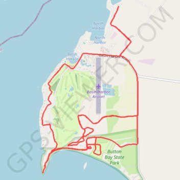
Basin Harbor trails
- Distance: 16.7 Km
- Elevation gain: 122 m
- Maximum elevation: 54 m
- Elevation loss: 122 m
- Minimum elevation: 29 m
- Moving time: 1 h 34 m
- Moving speed: 10.6 Km/h
- Maximum speed: 17.1 Km/h
- Total time: 1 h 54 m
- Global speed: 8.7 Km/h
Interactive trail map
Trail profile
- Distance: 16.7 Km
- Elevation gain: 122 m
- Maximum elevation: 54 m
- Elevation loss: 122 m
- Minimum elevation: 29 m
- Moving time: 1 h 34 m
- Moving speed: 10.6 Km/h
- Maximum speed: 17.1 Km/h
- Total time: 1 h 54 m
- Global speed: 8.7 Km/h
About this trail
Name: Basin Harbor trails trail, distance, elevation, map, profile, GPS track
Coordinates: 44.17844 -73.37094 44.20420 -73.35024
Other hiking, mountain biking, running and outdoor activity trails
Click on a trail to view its statistics, map and profile.