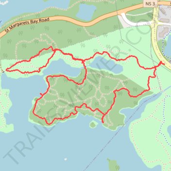
Long Lake Wilderness Loop Trail
- Distance: 5.1 Km
- Elevation gain: 73 m
- Maximum elevation: 79 m
- Elevation loss: 72 m
- Minimum elevation: 63 m
- Moving time: 1 h 26 m
- Moving speed: 3.5 Km/h
- Maximum speed: 6.0 Km/h
- Total time: 3 h 1 m
- Global speed: 1.7 Km/h
Interactive trail map
Trail profile
- Distance: 5.1 Km
- Elevation gain: 73 m
- Maximum elevation: 79 m
- Elevation loss: 72 m
- Minimum elevation: 63 m
- Moving time: 1 h 26 m
- Moving speed: 3.5 Km/h
- Maximum speed: 6.0 Km/h
- Total time: 3 h 1 m
- Global speed: 1.7 Km/h
About this trail
Name: Long Lake Wilderness Loop Trail trail, distance, elevation, map, profile, GPS track
Coordinates: 44.62837 -63.65288 44.63380 -63.63740
Other hiking, mountain biking, running and outdoor activity trails
Click on a trail to view its statistics, map and profile.
Long Lake Wilderness loop trail
Canada > Nova Scotia > Halifax County > Halifax
Distance: 2.7 Km • Elevation gain: 38 m • Maximum elevation: 83 m
Long Lake Wilderness Loop
Canada > Nova Scotia > Halifax County > Halifax
Distance: 3.8 Km • Elevation gain: 53 m • Maximum elevation: 79 m