Milne Park Fire trail
- Distance: 2.3 Km
- Elevation gain: 96 m
- Maximum elevation: 135 m
- Elevation loss: 96 m
- Minimum elevation: 38 m
- Moving time: 34 m 11 s
- Moving speed: 4.1 Km/h
- Maximum speed: 7.8 Km/h
- Total time: 41 m 7 s
- Global speed: 3.4 Km/h
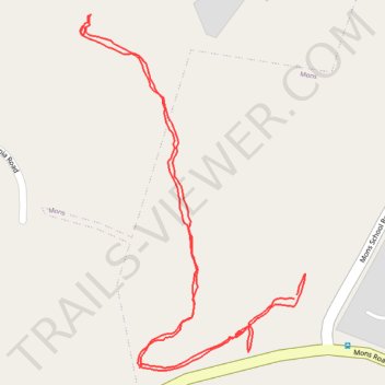
Interactive trail map
Trail profile
- Distance: 2.3 Km
- Elevation gain: 96 m
- Maximum elevation: 135 m
- Elevation loss: 96 m
- Minimum elevation: 38 m
- Moving time: 34 m 11 s
- Moving speed: 4.1 Km/h
- Maximum speed: 7.8 Km/h
- Total time: 41 m 7 s
- Global speed: 3.4 Km/h
About this trail
Name: Milne Park Fire trail trail, distance, elevation, map, profile, GPS track
Start: Mons School Road, Mons, Sunshine Coast Regional, Queensland, 4556, Australia (-26.68737 153.02067)
End: Mons School Road, Mons, Sunshine Coast Regional, Queensland, 4556, Australia (-26.68732 153.02071)
Coordinates: -26.68844 153.01712 -26.68316 153.02085
Topography: Sunshine Coast Regional topographic map, elevation, terrain
Other hiking, mountain biking, running and outdoor activity trails
Click on a trail to view its statistics, map and profile.
Imbil Jimna Kenilworth loop
Australia > Queensland > Tewantin
Distance: 216.0 Km • Elevation gain: 3,884 m • Maximum elevation: 822 m