Thank you for supporting this site ❤️
Make a donation
Make a donation
Gear up for your next adventure:
As an Amazon Associate, this site earns from qualifying purchases at no extra cost to you.
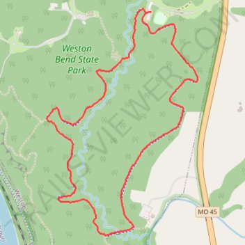
Weston Bend State Park Paved Loop
- Distance: 4.5 Km
- Elevation gain: 83 m
- Maximum elevation: 280 m
- Elevation loss: 84 m
- Minimum elevation: 240 m
- Moving time: 55 m 23 s
- Moving speed: 4.9 Km/h
- Maximum speed: 7.3 Km/h
- Total time: 56 m 36 s
- Global speed: 4.8 Km/h
Interactive trail map
Thank you for supporting this site ❤️
Make a donation
Make a donation
Gear up for your next adventure:
As an Amazon Associate, this site earns from qualifying purchases at no extra cost to you.
Trail profile
- Distance: 4.5 Km
- Elevation gain: 83 m
- Maximum elevation: 280 m
- Elevation loss: 84 m
- Minimum elevation: 240 m
- Moving time: 55 m 23 s
- Moving speed: 4.9 Km/h
- Maximum speed: 7.3 Km/h
- Total time: 56 m 36 s
- Global speed: 4.8 Km/h
Thank you for supporting this site ❤️
Make a donation
Make a donation
Gear up for your next adventure:
As an Amazon Associate, this site earns from qualifying purchases at no extra cost to you.
About this trail
Name: Weston Bend State Park Paved Loop trail, distance, elevation, map, profile, GPS track
Coordinates: 39.38021 -94.87588 39.39248 -94.86531
Thank you for supporting this site ❤️
Make a donation
Make a donation
Gear up for your next adventure:
As an Amazon Associate, this site earns from qualifying purchases at no extra cost to you.