Make a donation
Gear up for your next adventure:
As an Amazon Associate, this site earns from qualifying purchases at no extra cost to you.
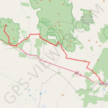
Langi Ghiran Park - Mount Buangor Park - Beaufort
#Bike
- Distance: 43.0 Km
- Elevation gain: 454 m
- Maximum elevation: 501 m
- Elevation loss: 474 m
- Minimum elevation: 339 m
Interactive trail map
Make a donation
Gear up for your next adventure:
As an Amazon Associate, this site earns from qualifying purchases at no extra cost to you.
Trail profile
- Distance: 43.0 Km
- Elevation gain: 454 m
- Maximum elevation: 501 m
- Elevation loss: 474 m
- Minimum elevation: 339 m
Make a donation
Gear up for your next adventure:
As an Amazon Associate, this site earns from qualifying purchases at no extra cost to you.
About this trail
Name: Langi Ghiran Park - Mount Buangor Park - Beaufort trail, distance, elevation, map, profile, GPS track
Start: Kartuk Road, Warrak, Rural City of Ararat, Victoria, 3377, Australia (-37.28979 143.09180)
End: 2, Albert Street, Beaufort, Shire of Pyrenees, Victoria, 3373, Australia (-37.42718 143.38213)
Coordinates: -37.42746 143.08425 -37.28979 143.38213
Topography: Victoria topographic map, elevation, terrain
Make a donation
Gear up for your next adventure:
As an Amazon Associate, this site earns from qualifying purchases at no extra cost to you.
Other hiking, mountain biking, running and outdoor activity trails
Click on a trail to view its statistics, map and profile.
Ararat - Langi Ghiran State Park
#Bike
Distance: 19.1 Km • Elevation gain: 211 m • Maximum elevation: 431 m