Mossy Cave, Little Windows and Turret Arch
Via Mossy Cave Trail in Bryce Canyon National Park #Hiking #Canyon #Rock #Arch #Forest #Waterfall #Overlook
- Distance: 1.4 Km
- Elevation gain: 64 m
- Maximum elevation: 2,128 m
- Elevation loss: 64 m
- Minimum elevation: 2,084 m
- Moving time: 23 m 55 s
- Moving speed: 3.4 Km/h
- Maximum speed: 5.1 Km/h
- Total time: 40 m 16 s
- Global speed: 2.0 Km/h
Interactive trail map
Trail profile
- Distance: 1.4 Km
- Elevation gain: 64 m
- Maximum elevation: 2,128 m
- Elevation loss: 64 m
- Minimum elevation: 2,084 m
- Moving time: 23 m 55 s
- Moving speed: 3.4 Km/h
- Maximum speed: 5.1 Km/h
- Total time: 40 m 16 s
- Global speed: 2.0 Km/h
About this trail
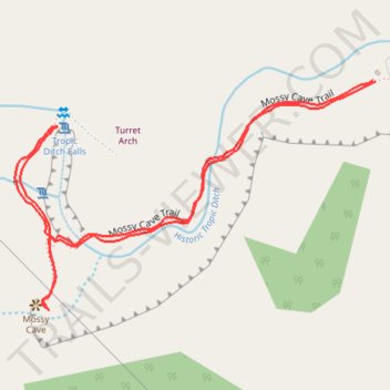
Name: Mossy Cave, Little Windows and Turret Arch trail, distance, elevation, map, profile, GPS track
Start: Mossy Cave Trail, Garfield County, Utah, 84776, United States (37.66575 -112.11056)
End: Mossy Cave Trail, Garfield County, Utah, 84776, United States (37.66577 -112.11059)
Coordinates: 37.66358 -112.11490 37.66577 -112.11056
Other hiking, mountain biking, running and outdoor activity trails
Click on a trail to view its statistics, map and profile.
Mossy Cave, Little Windows and Turret Arch Trail in Bryce Canyon National Park
United States > Utah > Garfield County
The Mossy Cave Trail in Bryce Canyon National Park offers an accessible hike that leads to a picturesque waterfall, the unique Mossy Cave, and views of the Little Windows formation. The trail is well-maintained and suitable for families and beginners, providing a short yet rewarding experience. Along the path,…
Distance: 1.4 Km • Elevation gain: 68 m • Maximum elevation: 2,130 m