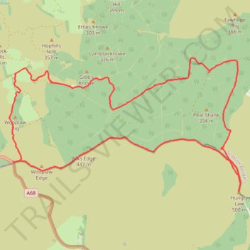
Hungry Law Loop From Parking
- Distance: 19.2 Km
- Elevation gain: 495 m
- Maximum elevation: 496 m
- Elevation loss: 495 m
- Minimum elevation: 241 m
- Moving time: 4 h 22 m
- Moving speed: 4.4 Km/h
- Maximum speed: 10.4 Km/h
- Total time: 5 h 8 m
- Global speed: 3.7 Km/h
Interactive trail map
Trail profile
- Distance: 19.2 Km
- Elevation gain: 495 m
- Maximum elevation: 496 m
- Elevation loss: 495 m
- Minimum elevation: 241 m
- Moving time: 4 h 22 m
- Moving speed: 4.4 Km/h
- Maximum speed: 10.4 Km/h
- Total time: 5 h 8 m
- Global speed: 3.7 Km/h
About this trail
Name: Hungry Law Loop From Parking trail, distance, elevation, map, profile, GPS track
Start: A68, Scottish Borders, Scotland, TD8 6PT, United Kingdom (55.35468 -2.47762)
End: A68, Scottish Borders, Scotland, TD8 6PT, United Kingdom (55.35466 -2.47763)
Coordinates: 55.34870 -2.47877 55.37493 -2.39954