Gravel Ride - Loch Leven Circular
- Distance: 20.0 Km
- Elevation gain: 108 m
- Maximum elevation: 125 m
- Elevation loss: 108 m
- Minimum elevation: 102 m
- Moving time: 1 h 31 m
- Moving speed: 13.2 Km/h
- Maximum speed: 28.1 Km/h
- Total time: 1 h 36 m
- Global speed: 12.5 Km/h
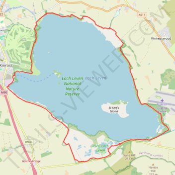
Interactive trail map
Trail profile
- Distance: 20.0 Km
- Elevation gain: 108 m
- Maximum elevation: 125 m
- Elevation loss: 108 m
- Minimum elevation: 102 m
- Moving time: 1 h 31 m
- Moving speed: 13.2 Km/h
- Maximum speed: 28.1 Km/h
- Total time: 1 h 36 m
- Global speed: 12.5 Km/h
About this trail
Name: Gravel Ride - Loch Leven Circular trail, distance, elevation, map, profile, GPS track
Start: Nan Walker Wynd, Kinross, Perth and Kinross, Scotland, KY13 8FF, United Kingdom (56.19946 -3.41746)
End: Nan Walker Wynd, Kinross, Perth and Kinross, Scotland, KY13 8FF, United Kingdom (56.19944 -3.41744)
Coordinates: 56.17184 -3.42110 56.22040 -3.32617