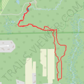
Tulip Loop Trail
- Distance: 4.1 Km
- Elevation gain: 50 m
- Maximum elevation: 359 m
- Elevation loss: 50 m
- Minimum elevation: 338 m
- Moving time: 1 h 45 s
- Moving speed: 4.0 Km/h
- Maximum speed: 8.3 Km/h
- Total time: 1 h 15 m
- Global speed: 3.2 Km/h
Interactive trail map
Trail profile
- Distance: 4.1 Km
- Elevation gain: 50 m
- Maximum elevation: 359 m
- Elevation loss: 50 m
- Minimum elevation: 338 m
- Moving time: 1 h 45 s
- Moving speed: 4.0 Km/h
- Maximum speed: 8.3 Km/h
- Total time: 1 h 15 m
- Global speed: 3.2 Km/h
About this trail
Name: Tulip Loop Trail trail, distance, elevation, map, profile, GPS track
Start: Waterfall Trail, Russell Township, Geauga County, Ohio, 44073, United States (41.45729 -81.32868)
End: Waterfall Trail, Russell Township, Geauga County, Ohio, 44073, United States (41.45727 -81.32873)
Coordinates: 41.44675 -81.33084 41.45729 -81.32212