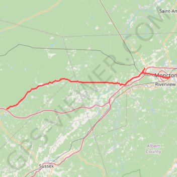
Coles Island - Moncton
- Distance: 90.9 Km
- Elevation gain: 587 m
- Maximum elevation: 135 m
- Elevation loss: 573 m
- Minimum elevation: 7 m
Interactive trail map
Trail profile
- Distance: 90.9 Km
- Elevation gain: 587 m
- Maximum elevation: 135 m
- Elevation loss: 573 m
- Minimum elevation: 7 m
About this trail
Name: Coles Island - Moncton trail, distance, elevation, map, profile, GPS track
Coordinates: 45.95874 -65.74479 46.12656 -64.77117
Other hiking, mountain biking, running and outdoor activity trails
Click on a trail to view its statistics, map and profile.
University of Moncton stroll
Canada > New Brunswick > Westmorland County > City of Moncton
Distance: 3.0 Km • Elevation gain: 17 m • Maximum elevation: 34 m
Dobson Hiking Trail - Laverty Falls
Canada > New Brunswick > Coverdale Parish > Riverview
Fundy National Park. #Hiking #Snowshoeing #Fundy
Distance: 62.2 Km • Elevation gain: 1,113 m • Maximum elevation: 403 m
Upper Kingsclear - Coles Island
Canada > New Brunswick > Kingsclear Parish
#Bike #UpperKingsclear #ColesIsland
Distance: 126.9 Km • Elevation gain: 704 m • Maximum elevation: 76 m