Thank you for supporting this site ❤️
Make a donation
Make a donation
Gear up for your next adventure:
As an Amazon Associate, this site earns from qualifying purchases at no extra cost to you.
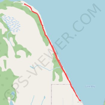
Gore Bay Lighthouse
Manitoulin Island. Lake Huron. #Hiking #Manitoulin #Huron
- Distance: 6.3 Km
- Elevation gain: 57 m
- Maximum elevation: 189 m
- Elevation loss: 57 m
- Minimum elevation: 175 m
Interactive trail map
Thank you for supporting this site ❤️
Make a donation
Make a donation
Gear up for your next adventure:
As an Amazon Associate, this site earns from qualifying purchases at no extra cost to you.
Trail profile
- Distance: 6.3 Km
- Elevation gain: 57 m
- Maximum elevation: 189 m
- Elevation loss: 57 m
- Minimum elevation: 175 m
Thank you for supporting this site ❤️
Make a donation
Make a donation
Gear up for your next adventure:
As an Amazon Associate, this site earns from qualifying purchases at no extra cost to you.
About this trail
Name: Gore Bay Lighthouse trail, distance, elevation, map, profile, GPS track
Coordinates: 45.92284 -82.48006 45.94593 -82.46085
Thank you for supporting this site ❤️
Make a donation
Make a donation
Gear up for your next adventure:
As an Amazon Associate, this site earns from qualifying purchases at no extra cost to you.