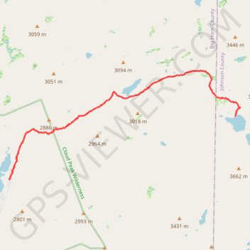
Lost Twin Lakes Trail
Big Horn County Trail Running
- Distance: 18.2 Km
- Elevation gain: 622 m
- Maximum elevation: 3,181 m
- Elevation loss: 622 m
- Minimum elevation: 2,782 m
- Moving time: 2 h 59 m
- Moving speed: 6.1 Km/h
- Maximum speed: 15.2 Km/h
- Total time: 3 h 29 m
- Global speed: 5.2 Km/h
Interactive trail map
Trail profile
- Distance: 18.2 Km
- Elevation gain: 622 m
- Maximum elevation: 3,181 m
- Elevation loss: 622 m
- Minimum elevation: 2,782 m
- Moving time: 2 h 59 m
- Moving speed: 6.1 Km/h
- Maximum speed: 15.2 Km/h
- Total time: 3 h 29 m
- Global speed: 5.2 Km/h
About this trail
Name: Lost Twin Lakes Trail trail, distance, elevation, map, profile, GPS track
Start: Mistymoon Trail, Big Horn County, Wyoming, United States (44.26248 -107.21280)
End: Mistymoon Trail, Big Horn County, Wyoming, United States (44.26245 -107.21276)
Coordinates: 44.26245 -107.21280 44.28848 -107.13572