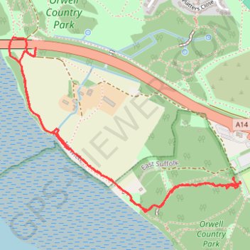
Orwell Bridge to Bridge Wood Coast Path
- Distance: 3.3 Km
- Elevation gain: 56 m
- Maximum elevation: 36 m
- Elevation loss: 56 m
- Minimum elevation: 0 m
- Moving time: 59 m 32 s
- Moving speed: 3.3 Km/h
- Maximum speed: 8.4 Km/h
- Total time: 1 h 7 s
- Global speed: 3.3 Km/h
Interactive trail map
Trail profile
- Distance: 3.3 Km
- Elevation gain: 56 m
- Maximum elevation: 36 m
- Elevation loss: 56 m
- Minimum elevation: 0 m
- Moving time: 59 m 32 s
- Moving speed: 3.3 Km/h
- Maximum speed: 8.4 Km/h
- Total time: 1 h 7 s
- Global speed: 3.3 Km/h
About this trail
Name: Orwell Bridge to Bridge Wood Coast Path trail, distance, elevation, map, profile, GPS track
Coordinates: 52.02056 1.17264 52.02721 1.18696
Other hiking, mountain biking, running and outdoor activity trails
Click on a trail to view its statistics, map and profile.
England Coast Path Eastwards from Bridge Wood
United Kingdom > England > Suffolk > Ipswich
Distance: 5.4 Km • Elevation gain: 73 m • Maximum elevation: 36 m