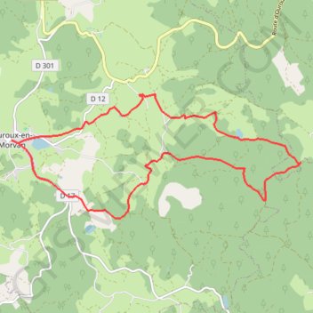
Le maquis Bernard
- Distance: 15.2 Km
- Elevation gain: 342 m
- Maximum elevation: 637 m
- Elevation loss: 342 m
- Minimum elevation: 477 m
Interactive trail map
Trail profile
- Distance: 15.2 Km
- Elevation gain: 342 m
- Maximum elevation: 637 m
- Elevation loss: 342 m
- Minimum elevation: 477 m
About this trail
Name: Le maquis Bernard trail, distance, elevation, map, profile, GPS track
Coordinates: 47.17265 3.94561 47.19359 4.01719
Other hiking, mountain biking, running and outdoor activity trails
Click on a trail to view its statistics, map and profile.
PT23DS2 Lörrach → Cadaqués
Germany > Baden-Württemberg > Landkreis Lörrach > Lörrach (Kernstadt)
Distance: 1,050.7 Km • Elevation gain: 13,130 m • Maximum elevation: 1,505 m
GR 654 - Le chemin vers Saint-Jacques-de-Compostelle via Vézelay
France > Nouvelle-Aquitaine > Dordogne > Bergerac
Distance: 810.9 Km • Elevation gain: 9,631 m • Maximum elevation: 670 m