Munro hillwalk Glas Leathad Mor
Munro, hillwalk, Glas, Leathad, Mor
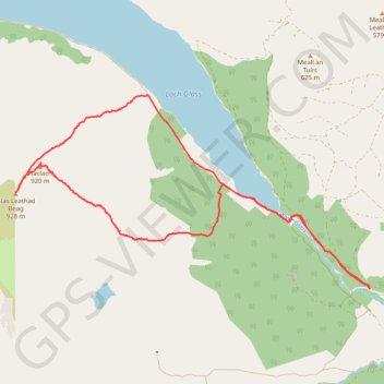
- Distance: 16.8 Km
- Elevation gain: 835 m
- Maximum elevation: 926 m
- Elevation loss: 835 m
- Minimum elevation: 209 m
- Moving time: 4 h 53 m
- Moving speed: 3.4 Km/h
- Maximum speed: 20.4 Km/h
- Total time: 5 h 41 m
- Global speed: 2.9 Km/h
Interactive trail map
Trail profile
- Distance: 16.8 Km
- Elevation gain: 835 m
- Maximum elevation: 926 m
- Elevation loss: 835 m
- Minimum elevation: 209 m
- Moving time: 4 h 53 m
- Moving speed: 3.4 Km/h
- Maximum speed: 20.4 Km/h
- Total time: 5 h 41 m
- Global speed: 2.9 Km/h
About this trail
Name: Munro hillwalk Glas Leathad Mor trail, distance, elevation, map, profile, GPS track
Start: Evanton, Highland, Scotland, IV16 9XA, United Kingdom (57.68696 -4.43713)
End: Evanton, Highland, Scotland, IV16 9XW, United Kingdom (57.68691 -4.43702)
Coordinates: 57.68690 -4.53187 57.71456 -4.43696