Make a donation
Gear up for your next adventure:
As an Amazon Associate, this site earns from qualifying purchases at no extra cost to you.
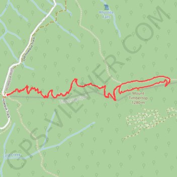
Mount Timbertop
- Distance: 6.0 Km
- Elevation gain: 436 m
- Maximum elevation: 1,267 m
- Elevation loss: 436 m
- Minimum elevation: 861 m
- Moving time: 1 h 47 m
- Moving speed: 3.3 Km/h
- Maximum speed: 6.5 Km/h
- Total time: 1 h 57 m
- Global speed: 3.1 Km/h
Interactive trail map
Make a donation
Gear up for your next adventure:
As an Amazon Associate, this site earns from qualifying purchases at no extra cost to you.
Trail profile
- Distance: 6.0 Km
- Elevation gain: 436 m
- Maximum elevation: 1,267 m
- Elevation loss: 436 m
- Minimum elevation: 861 m
- Moving time: 1 h 47 m
- Moving speed: 3.3 Km/h
- Maximum speed: 6.5 Km/h
- Total time: 1 h 57 m
- Global speed: 3.1 Km/h
Make a donation
Gear up for your next adventure:
As an Amazon Associate, this site earns from qualifying purchases at no extra cost to you.
About this trail
Name: Mount Timbertop trail, distance, elevation, map, profile, GPS track
Start: Old Howqua Track, Howqua Hills, Shire of Mansfield, Victoria, 3723, Australia (-37.15380 146.30427)
End: Old Howqua Track, Howqua Hills, Shire of Mansfield, Victoria, 3723, Australia (-37.15377 146.30419)
Coordinates: -37.15428 146.30416 -37.15215 146.32240
Topography: Victoria topographic map, elevation, terrain
Make a donation
Gear up for your next adventure:
As an Amazon Associate, this site earns from qualifying purchases at no extra cost to you.
Other hiking, mountain biking, running and outdoor activity trails
Click on a trail to view its statistics, map and profile.
Mount Timbertop Trail
Distance: 5.8 Km • Elevation gain: 431 m • Maximum elevation: 1,267 m