Mooresville Run
Cornelius Road Park
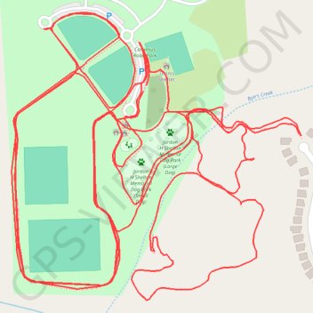
- Distance: 8.1 Km
- Elevation gain: 69 m
- Maximum elevation: 272 m
- Elevation loss: 69 m
- Minimum elevation: 257 m
- Moving time: 1 h 6 m
- Moving speed: 7.3 Km/h
- Maximum speed: 11.2 Km/h
- Total time: 1 h 6 m
- Global speed: 7.3 Km/h
Interactive trail map
Trail profile
- Distance: 8.1 Km
- Elevation gain: 69 m
- Maximum elevation: 272 m
- Elevation loss: 69 m
- Minimum elevation: 257 m
- Moving time: 1 h 6 m
- Moving speed: 7.3 Km/h
- Maximum speed: 11.2 Km/h
- Total time: 1 h 6 m
- Global speed: 7.3 Km/h
About this trail
Name: Mooresville Run trail, distance, elevation, map, profile, GPS track
Start: Cornelius Road, Iredell County, North Carolina, United States (35.61395 -80.84383)
End: Cornelius Road, Iredell County, North Carolina, United States (35.61405 -80.84377)
Coordinates: 35.61037 -80.84661 35.61530 -80.84051
Other hiking, mountain biking, running and outdoor activity trails
Click on a trail to view its statistics, map and profile.
Cornelius Road Park loop
United States > North Carolina > Iredell County
Distance: 2.3 Km • Elevation gain: 12 m • Maximum elevation: 272 m
Mooresville Trail Run
United States > North Carolina > Iredell County
Distance: 4.2 Km • Elevation gain: 50 m • Maximum elevation: 272 m