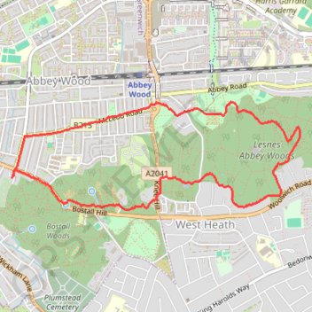
Lesnes Abbey Woods
Morning Walk
- Distance: 6.2 Km
- Elevation gain: 103 m
- Maximum elevation: 68 m
- Elevation loss: 104 m
- Minimum elevation: 8 m
- Moving time: 1 h 14 m
- Moving speed: 4.9 Km/h
- Maximum speed: 8.6 Km/h
- Total time: 1 h 14 m
- Global speed: 4.9 Km/h
Interactive trail map
Trail profile
- Distance: 6.2 Km
- Elevation gain: 103 m
- Maximum elevation: 68 m
- Elevation loss: 104 m
- Minimum elevation: 8 m
- Moving time: 1 h 14 m
- Moving speed: 4.9 Km/h
- Maximum speed: 8.6 Km/h
- Total time: 1 h 14 m
- Global speed: 4.9 Km/h
About this trail
Name: Lesnes Abbey Woods trail, distance, elevation, map, profile, GPS track
Coordinates: 51.48186 0.10616 51.48925 0.13776
Other hiking, mountain biking, running and outdoor activity trails
Click on a trail to view its statistics, map and profile.
Oxleas Woods
United Kingdom > England > London
Morning Walk
Distance: 10.8 Km • Elevation gain: 149 m • Maximum elevation: 128 m
Bostall Woods to Danson Park Loop Run
United Kingdom > England > London
Distance: 12.0 Km • Elevation gain: 119 m • Maximum elevation: 67 m
Erith Marshes
United Kingdom > England > London
Morning Walk
Distance: 9.0 Km • Elevation gain: 106 m • Maximum elevation: 73 m
Lesnes Abbey Park
United Kingdom > England > London
Morning Walk
Distance: 6.7 Km • Elevation gain: 88 m • Maximum elevation: 73 m
Danson Park
United Kingdom > England > London
Morning Walk
Distance: 8.5 Km • Elevation gain: 90 m • Maximum elevation: 66 m
Woolwich Common
United Kingdom > England > London
Morning Walk
Distance: 11.4 Km • Elevation gain: 134 m • Maximum elevation: 66 m
Shrewsbury Park
United Kingdom > England > London
Morning Walk
Distance: 7.4 Km • Elevation gain: 121 m • Maximum elevation: 93 m
Woolwich Common
United Kingdom > England > London
Morning Walk
Distance: 14.4 Km • Elevation gain: 202 m • Maximum elevation: 117 m
Crossway Park
United Kingdom > England > London
Morning Run
Distance: 9.6 Km • Elevation gain: 38 m • Maximum elevation: 22 m
Crossway Park
United Kingdom > England > London
Morning Run
Distance: 9.5 Km • Elevation gain: 37 m • Maximum elevation: 23 m
Shooters Hill
United Kingdom > England > London
Morning Walk
Distance: 9.1 Km • Elevation gain: 143 m • Maximum elevation: 127 m
Thamesmead
United Kingdom > England > London
Morning Run
Distance: 6.7 Km • Elevation gain: 24 m • Maximum elevation: 21 m
Thamesmead
United Kingdom > England > London
Lunch Walk
Distance: 9.5 Km • Elevation gain: 86 m • Maximum elevation: 67 m