Thank you for supporting this site ❤️
Make a donation
Make a donation
Gear up for your next adventure:
🧦Merino Wool Hiking Socks - Moisture-wicking socks to prevent blisters during long topographic surveys
🧭Military Style Lensatic Compass - Durable sighting compasses for advanced land navigation and surveying
As an Amazon Associate, this site earns from qualifying purchases at no extra cost to you.
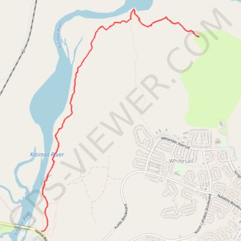
Fishermen's Trail
Kitimat River. #Hiking
- Distance: 10.6 Km
- Elevation gain: 350 m
- Maximum elevation: 90 m
- Elevation loss: 350 m
- Minimum elevation: 24 m
Interactive trail map
Thank you for supporting this site ❤️
Make a donation
Make a donation
Gear up for your next adventure:
As an Amazon Associate, this site earns from qualifying purchases at no extra cost to you.
Trail profile
- Distance: 10.6 Km
- Elevation gain: 350 m
- Maximum elevation: 90 m
- Elevation loss: 350 m
- Minimum elevation: 24 m
Thank you for supporting this site ❤️
Make a donation
Make a donation
Gear up for your next adventure:
As an Amazon Associate, this site earns from qualifying purchases at no extra cost to you.
About this trail
Name: Fishermen's Trail trail, distance, elevation, map, profile, GPS track
Coordinates: 54.05849 -128.67303 54.08630 -128.63943
Thank you for supporting this site ❤️
Make a donation
Make a donation
Gear up for your next adventure:
As an Amazon Associate, this site earns from qualifying purchases at no extra cost to you.