Thank you for supporting this site ❤️
Make a donation
Make a donation
Gear up for your next adventure:
As an Amazon Associate, this site earns from qualifying purchases at no extra cost to you.
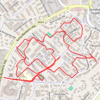
Trondheim Running
- Distance: 6.3 Km
- Elevation gain: 79 m
- Maximum elevation: 88 m
- Elevation loss: 80 m
- Minimum elevation: 58 m
- Moving time: 27 m 32 s
- Moving speed: 13.8 Km/h
- Maximum speed: 23.1 Km/h
- Total time: 30 m 45 s
- Global speed: 12.4 Km/h
Interactive trail map
Thank you for supporting this site ❤️
Make a donation
Make a donation
Gear up for your next adventure:
As an Amazon Associate, this site earns from qualifying purchases at no extra cost to you.
Trail profile
- Distance: 6.3 Km
- Elevation gain: 79 m
- Maximum elevation: 88 m
- Elevation loss: 80 m
- Minimum elevation: 58 m
- Moving time: 27 m 32 s
- Moving speed: 13.8 Km/h
- Maximum speed: 23.1 Km/h
- Total time: 30 m 45 s
- Global speed: 12.4 Km/h
Thank you for supporting this site ❤️
Make a donation
Make a donation
Gear up for your next adventure:
As an Amazon Associate, this site earns from qualifying purchases at no extra cost to you.
About this trail
Name: Trondheim Running trail, distance, elevation, map, profile, GPS track
Coordinates: 63.42499 10.44139 63.42937 10.45569
Thank you for supporting this site ❤️
Make a donation
Make a donation
Gear up for your next adventure:
As an Amazon Associate, this site earns from qualifying purchases at no extra cost to you.