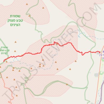
Ramon to Sapir
מכתש רמון לספיר: ריצה חוצה מדבריות: מהר הנגב אל הערבה
- Distance: 36.2 Km
- Elevation gain: 856 m
- Maximum elevation: 547 m
- Elevation loss: 1,330 m
- Minimum elevation: -31 m
- Moving time: 10 h 28 m
- Moving speed: 3.5 Km/h
- Maximum speed: 4.1 Km/h
- Total time: 10 h 28 m
- Global speed: 3.5 Km/h
Interactive trail map
Trail profile
- Distance: 36.2 Km
- Elevation gain: 856 m
- Maximum elevation: 547 m
- Elevation loss: 1,330 m
- Minimum elevation: -31 m
- Moving time: 10 h 28 m
- Moving speed: 3.5 Km/h
- Maximum speed: 4.1 Km/h
- Total time: 10 h 28 m
- Global speed: 3.5 Km/h
About this trail
Name: Ramon to Sapir trail, distance, elevation, map, profile, GPS track
Coordinates: 30.59161 34.91812 30.64088 35.19063
Other hiking, mountain biking, running and outdoor activity trails
Click on a trail to view its statistics, map and profile.
Mount Ardon to Mitzpe Ramon
Israel > South District > Ramat Negev Regional Council
הר ארדון למצפה רמון: מעלה מחמל וקו פנורמי ארוך מעל מכתש רמון
Distance: 32.8 Km • Elevation gain: 978 m • Maximum elevation: 841 m
Mount Katom and Shen Ramon
Israel > South District > Ramat Negev Regional Council
הר קטום ושן רמון: מההר שולחן של מכתש רמון למצפה רמון
Distance: 26.1 Km • Elevation gain: 1,106 m • Maximum elevation: 865 m
צופר- פוביצר
Israel > South District > Arava Tichona Regional Council > Zofar
Distance: 42.8 Km • Elevation gain: 887 m • Maximum elevation: 359 m