Thank you for supporting this site ❤️
Make a donation
Make a donation
Gear up for your next adventure:
As an Amazon Associate, this site earns from qualifying purchases at no extra cost to you.
Tenaja Falls
Interactive trail map
Thank you for supporting this site ❤️
Make a donation
Make a donation
Gear up for your next adventure:
As an Amazon Associate, this site earns from qualifying purchases at no extra cost to you.
Trail profile
- Distance: 7.0 Km
- Elevation gain: 256 m
- Maximum elevation: 488 m
- Elevation loss: 239 m
- Minimum elevation: 338 m
Thank you for supporting this site ❤️
Make a donation
Make a donation
Gear up for your next adventure:
As an Amazon Associate, this site earns from qualifying purchases at no extra cost to you.
About this trail
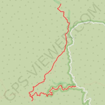
Name: Tenaja Falls trail, distance, elevation, map, profile, GPS track
Start: Fisherman's Camp Trail, Riverside County, California, United States (33.53231 -117.39301)
End: Tenaja Falls Trail, Riverside County, California, United States (33.55640 -117.39831)
Coordinates: 33.52801 -117.40952 33.55640 -117.39301
Thank you for supporting this site ❤️
Make a donation
Make a donation
Gear up for your next adventure:
As an Amazon Associate, this site earns from qualifying purchases at no extra cost to you.