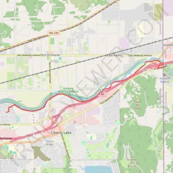
Part of Spokane River Centennial Trail
- Distance: 19.4 Km
- Elevation gain: 71 m
- Maximum elevation: 633 m
- Elevation loss: 71 m
- Minimum elevation: 613 m
- Moving time: 53 m 44 s
- Moving speed: 21.6 Km/h
- Maximum speed: 35.6 Km/h
- Total time: 55 m 29 s
- Global speed: 20.9 Km/h
Interactive trail map
Trail profile
- Distance: 19.4 Km
- Elevation gain: 71 m
- Maximum elevation: 633 m
- Elevation loss: 71 m
- Minimum elevation: 613 m
- Moving time: 53 m 44 s
- Moving speed: 21.6 Km/h
- Maximum speed: 35.6 Km/h
- Total time: 55 m 29 s
- Global speed: 20.9 Km/h
About this trail
Name: Part of Spokane River Centennial Trail trail, distance, elevation, map, profile, GPS track
Coordinates: 47.67629 -117.13873 47.69820 -117.03942
Other hiking, mountain biking, running and outdoor activity trails
Click on a trail to view its statistics, map and profile.
Trails in Harvard Park area along Spokane River near Liberty Lake
United States > Washington > Spokane County > Otis Orchards-East Farms
Distance: 4.0 Km • Elevation gain: 25 m • Maximum elevation: 618 m