Thank you for supporting this site ❤️
Make a donation
Make a donation
Gear up for your next adventure:
As an Amazon Associate, this site earns from qualifying purchases at no extra cost to you.
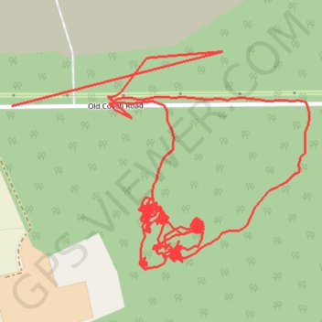
RE SK620770 2
- Distance: 4.8 Km
- Elevation gain: 11 m
- Maximum elevation: 63 m
- Elevation loss: 10 m
- Minimum elevation: 58 m
Interactive trail map
Thank you for supporting this site ❤️
Make a donation
Make a donation
Gear up for your next adventure:
As an Amazon Associate, this site earns from qualifying purchases at no extra cost to you.
Trail profile
- Distance: 4.8 Km
- Elevation gain: 11 m
- Maximum elevation: 63 m
- Elevation loss: 10 m
- Minimum elevation: 58 m
Thank you for supporting this site ❤️
Make a donation
Make a donation
Gear up for your next adventure:
As an Amazon Associate, this site earns from qualifying purchases at no extra cost to you.
About this trail
Name: RE SK620770 2 trail, distance, elevation, map, profile, GPS track
Coordinates: 53.28632 -1.07488 53.28970 -1.06715
Thank you for supporting this site ❤️
Make a donation
Make a donation
Gear up for your next adventure:
As an Amazon Associate, this site earns from qualifying purchases at no extra cost to you.