Keller-Kirn Park
- Distance: 1.7 Km
- Elevation gain: 46 m
- Maximum elevation: 345 m
- Elevation loss: 46 m
- Minimum elevation: 307 m
- Moving time: 22 m 22 s
- Moving speed: 4.5 Km/h
- Maximum speed: 8.3 Km/h
- Total time: 26 m 37 s
- Global speed: 3.8 Km/h
Interactive trail map
Trail profile
- Distance: 1.7 Km
- Elevation gain: 46 m
- Maximum elevation: 345 m
- Elevation loss: 46 m
- Minimum elevation: 307 m
- Moving time: 22 m 22 s
- Moving speed: 4.5 Km/h
- Maximum speed: 8.3 Km/h
- Total time: 26 m 37 s
- Global speed: 3.8 Km/h
About this trail
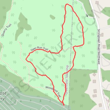
Name: Keller-Kirn Park trail, distance, elevation, map, profile, GPS track
Coordinates: 39.73214 -82.60291 39.73761 -82.59884
Other hiking, mountain biking, running and outdoor activity trails
Click on a trail to view its statistics, map and profile.
Keller Kirn outer loop trail (with entrance from cemetery)
United States > Ohio > Fairfield County > Lancaster
Distance: 2.2 Km • Elevation gain: 50 m • Maximum elevation: 348 m