Port Moody - Shoreline Trail
Interactive trail map
Trail profile
- Distance: 5.8 Km
- Elevation gain: 78 m
- Maximum elevation: 15 m
- Elevation loss: 78 m
- Minimum elevation: 0 m
About this trail
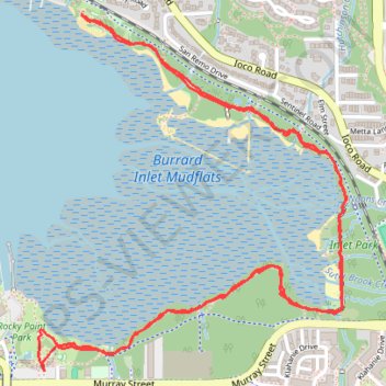
Name: Port Moody - Shoreline Trail trail, distance, elevation, map, profile, GPS track
Coordinates: 49.27920 -122.84867 49.28972 -122.83475
Other hiking, mountain biking, running and outdoor activity trails
Click on a trail to view its statistics, map and profile.