Import a GPX file

Leona Fire Trail

Oakland Walking. #Hiking #Walking #Trail

  • Distance: 2.3 Km
  • Elevation gain: 209 m
  • Maximum elevation: 248 m
  • Elevation loss: 206 m
  • Minimum elevation: 95 m
  • Moving time: 39 m 32 s
  • Moving speed: 3.6 Km/h
  • Maximum speed: 9.8 Km/h
  • Total time: 57 m 19 s
  • Global speed: 2.5 Km/h

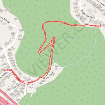
Interactive trail map

Trail profile

  • Distance: 2.3 Km
  • Elevation gain: 209 m
  • Maximum elevation: 248 m
  • Elevation loss: 206 m
  • Minimum elevation: 95 m
  • Moving time: 39 m 32 s
  • Moving speed: 3.6 Km/h
  • Maximum speed: 9.8 Km/h
  • Total time: 57 m 19 s
  • Global speed: 2.5 Km/h

About this trail

Gear up for your next adventure:

🔦Powerful LED Headlamps - Hands-free lighting for night navigation and setting up camp after dark
🧼Biodegradable Outdoor Soap - Clean gear and yourself without harming the local ecosystem
🧦Hiking Socks - Comfortable socks for long hikes
🛌Compact Down Sleeping Bags - Warmth without the bulk, ideal for backcountry camping
🗺️Topographic Maps - Detailed maps for hiking and navigation

As an Amazon Associate, this site earns from qualifying purchases at no extra cost to you.