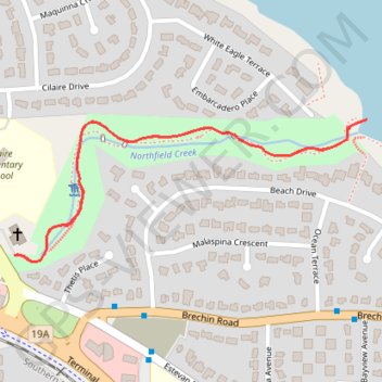
Beach Estates Park
Northfield Creek. Departure Bay. #Hiking #Running #BeachEstates
- Distance: 1.7 Km
- Elevation gain: 66 m
- Maximum elevation: 68 m
- Elevation loss: 66 m
- Minimum elevation: 2 m
Interactive trail map
Trail profile
- Distance: 1.7 Km
- Elevation gain: 66 m
- Maximum elevation: 68 m
- Elevation loss: 66 m
- Minimum elevation: 2 m
About this trail
Name: Beach Estates Park trail, distance, elevation, map, profile, GPS track
Coordinates: 49.19106 -123.96562 49.19322 -123.95741