Thank you for supporting this site ❤️
Make a donation
Make a donation
Gear up for your next adventure:
As an Amazon Associate, this site earns from qualifying purchases at no extra cost to you.
Paths on Iona
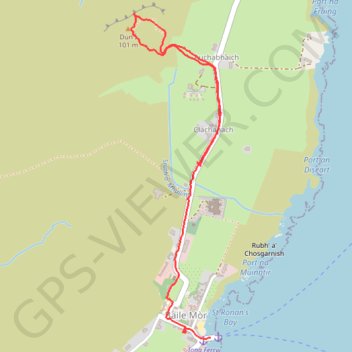
Interactive trail map
Thank you for supporting this site ❤️
Make a donation
Make a donation
Gear up for your next adventure:
As an Amazon Associate, this site earns from qualifying purchases at no extra cost to you.
Trail profile
- Distance: 2.8 Km
- Elevation gain: 74 m
- Maximum elevation: 96 m
- Elevation loss: 100 m
- Minimum elevation: 0 m
- Moving time: 58 m 16 s
- Moving speed: 2.9 Km/h
- Maximum speed: 7.8 Km/h
- Total time: 1 h 34 m
- Global speed: 1.8 Km/h
Thank you for supporting this site ❤️
Make a donation
Make a donation
Gear up for your next adventure:
As an Amazon Associate, this site earns from qualifying purchases at no extra cost to you.
About this trail
Name: Paths on Iona trail, distance, elevation, map, profile, GPS track
Start: Auchabhaich, The Village, Argyll and Bute, Scotland, PA76 6SW, United Kingdom (56.33657 -6.39258)
Coordinates: 56.33035 -6.39677 56.34186 -6.39105
Thank you for supporting this site ❤️
Make a donation
Make a donation
Gear up for your next adventure:
As an Amazon Associate, this site earns from qualifying purchases at no extra cost to you.