Make a donation
Gear up for your next adventure:
As an Amazon Associate, this site earns from qualifying purchases at no extra cost to you.
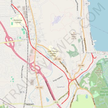
Rail Trail Walk, Blauvelt Orangeburg
- Distance: 12.8 Km
- Elevation gain: 101 m
- Maximum elevation: 60 m
- Elevation loss: 115 m
- Minimum elevation: 5 m
- Moving time: 2 h 5 m
- Moving speed: 6.1 Km/h
- Maximum speed: 22.5 Km/h
- Total time: 2 h 5 m
- Global speed: 6.1 Km/h
Interactive trail map
Make a donation
Gear up for your next adventure:
As an Amazon Associate, this site earns from qualifying purchases at no extra cost to you.
Trail profile
- Distance: 12.8 Km
- Elevation gain: 101 m
- Maximum elevation: 60 m
- Elevation loss: 115 m
- Minimum elevation: 5 m
- Moving time: 2 h 5 m
- Moving speed: 6.1 Km/h
- Maximum speed: 22.5 Km/h
- Total time: 2 h 5 m
- Global speed: 6.1 Km/h
Make a donation
Gear up for your next adventure:
As an Amazon Associate, this site earns from qualifying purchases at no extra cost to you.
About this trail
Name: Rail Trail Walk, Blauvelt Orangeburg trail, distance, elevation, map, profile, GPS track
Coordinates: 41.02253 -73.95742 41.05962 -73.91568
Make a donation
Gear up for your next adventure:
As an Amazon Associate, this site earns from qualifying purchases at no extra cost to you.
Other hiking, mountain biking, running and outdoor activity trails
Click on a trail to view its statistics, map and profile.
Mount Nebo to Blauvelt State Park via Long Path Green Trail
United States > New York > Rockland County > Blauvelt
Distance: 19.1 Km • Elevation gain: 445 m • Maximum elevation: 200 m
Clausland Mountain County Park loop
United States > New York > Rockland County > Blauvelt
Distance: 6.6 Km • Elevation gain: 173 m • Maximum elevation: 200 m
Old Croton Aqueduct Trail and Bronx
United States > New York > Westchester County > Village of Croton-on-Hudson
Distance: 70.8 Km • Elevation gain: 823 m • Maximum elevation: 80 m
Make a donation
Gear up for your next adventure:
As an Amazon Associate, this site earns from qualifying purchases at no extra cost to you.
Nebo Clausland Tackamac Blauvelt
United States > New York > Rockland County > Orangeburg
Distance: 19.0 Km • Elevation gain: 478 m • Maximum elevation: 201 m
Blauvelt State Park
United States > New York > Rockland County > Blauvelt
Distance: 18.8 Km • Elevation gain: 434 m • Maximum elevation: 200 m