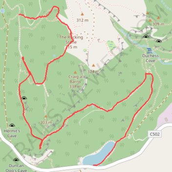
Tracks, MTB and off track sections to visit the Rocking Stone and Polney Crag
- Distance: 3.6 Km
- Elevation gain: 172 m
- Maximum elevation: 321 m
- Elevation loss: 294 m
- Minimum elevation: 103 m
Interactive trail map
Trail profile
- Distance: 3.6 Km
- Elevation gain: 172 m
- Maximum elevation: 321 m
- Elevation loss: 294 m
- Minimum elevation: 103 m
About this trail
Name: Tracks, MTB and off track sections to visit the Rocking Stone and Polney Crag trail, distance, elevation, map, profile, GPS track
End: C502, Dunkeld, Perth and Kinross, Scotland, PH8 0HX, United Kingdom (56.56914 -3.60597)
Coordinates: 56.56914 -3.61366 56.57823 -3.59978
Other hiking, mountain biking, running and outdoor activity trails
Click on a trail to view its statistics, map and profile.
Falls of the Braan and River Tay loop trail
United Kingdom > Scotland > Perth and Kinross > Dunkeld > Inchmagrannachan
Distance: 10.9 Km • Elevation gain: 234 m • Maximum elevation: 186 m
Walk over A9 bridge over River Braan by pedestrian pavement (sidewalk) and small diversion for SGN gas pipeline route then Fiddlers path
United Kingdom > Scotland > Perth and Kinross > Dunkeld
Distance: 6.0 Km • Elevation gain: 79 m • Maximum elevation: 76 m
Craigvinean Forest Loop MTB, Dunkeld, Perthshire
United Kingdom > Scotland > Perth and Kinross > Inver
Mountain Bike Ride, UK, Perthshire, Dunkeld
Distance: 21.3 Km • Elevation gain: 562 m • Maximum elevation: 362 m
EMTB Gravel: Murthly - Birnam - Loop
United Kingdom > Scotland > Perth and Kinross > Newlands
Around Dunkeld, Perthshire Scotland
Distance: 46.4 Km • Elevation gain: 869 m • Maximum elevation: 305 m
Around Loch Ordie
United Kingdom > Scotland > Perth and Kinross
Mountain Bike Ride, UK, Perthshire, Dunkeld
Distance: 35.8 Km • Elevation gain: 579 m • Maximum elevation: 300 m