Thank you for supporting this site ❤️
Make a donation
Make a donation
Gear up for your next adventure:
As an Amazon Associate, this site earns from qualifying purchases at no extra cost to you.
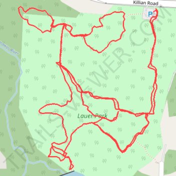
Lauer Park Trails
- Distance: 3.3 Km
- Elevation gain: 39 m
- Maximum elevation: 338 m
- Elevation loss: 40 m
- Minimum elevation: 325 m
- Moving time: 56 m 40 s
- Moving speed: 3.5 Km/h
- Maximum speed: 5.8 Km/h
- Total time: 59 m 43 s
- Global speed: 3.3 Km/h
Interactive trail map
Thank you for supporting this site ❤️
Make a donation
Make a donation
Gear up for your next adventure:
As an Amazon Associate, this site earns from qualifying purchases at no extra cost to you.
Trail profile
- Distance: 3.3 Km
- Elevation gain: 39 m
- Maximum elevation: 338 m
- Elevation loss: 40 m
- Minimum elevation: 325 m
- Moving time: 56 m 40 s
- Moving speed: 3.5 Km/h
- Maximum speed: 5.8 Km/h
- Total time: 59 m 43 s
- Global speed: 3.3 Km/h
Thank you for supporting this site ❤️
Make a donation
Make a donation
Gear up for your next adventure:
As an Amazon Associate, this site earns from qualifying purchases at no extra cost to you.
About this trail
Name: Lauer Park Trails trail, distance, elevation, map, profile, GPS track
Coordinates: 40.99242 -81.42688 40.99559 -81.42329
Thank you for supporting this site ❤️
Make a donation
Make a donation
Gear up for your next adventure:
As an Amazon Associate, this site earns from qualifying purchases at no extra cost to you.