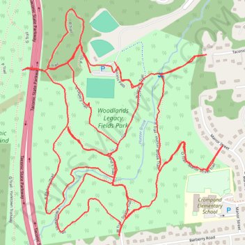
Woodlands Legacy Field Park trails
- Distance: 8.5 Km
- Elevation gain: 177 m
- Maximum elevation: 174 m
- Elevation loss: 176 m
- Minimum elevation: 121 m
- Moving time: 1 h 30 m
- Moving speed: 5.7 Km/h
- Maximum speed: 13.5 Km/h
- Total time: 1 h 30 m
- Global speed: 5.7 Km/h
Interactive trail map
Trail profile
- Distance: 8.5 Km
- Elevation gain: 177 m
- Maximum elevation: 174 m
- Elevation loss: 176 m
- Minimum elevation: 121 m
- Moving time: 1 h 30 m
- Moving speed: 5.7 Km/h
- Maximum speed: 13.5 Km/h
- Total time: 1 h 30 m
- Global speed: 5.7 Km/h
About this trail
Name: Woodlands Legacy Field Park trails trail, distance, elevation, map, profile, GPS track
Coordinates: 41.30329 -73.82463 41.31197 -73.81444
Other hiking, mountain biking, running and outdoor activity trails
Click on a trail to view its statistics, map and profile.