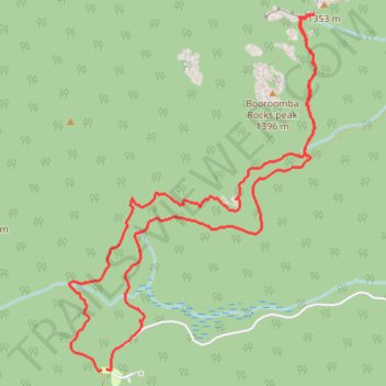
Honeysuckle Creek Tracking Station to Booroomba Rocks
- Distance: 10.7 Km
- Elevation gain: 376 m
- Maximum elevation: 1,336 m
- Elevation loss: 376 m
- Minimum elevation: 1,052 m
- Moving time: 1 h 26 m
- Moving speed: 7.5 Km/h
- Maximum speed: 14.3 Km/h
- Total time: 1 h 28 m
- Global speed: 7.3 Km/h
Interactive trail map
Trail profile
- Distance: 10.7 Km
- Elevation gain: 376 m
- Maximum elevation: 1,336 m
- Elevation loss: 376 m
- Minimum elevation: 1,052 m
- Moving time: 1 h 26 m
- Moving speed: 7.5 Km/h
- Maximum speed: 14.3 Km/h
- Total time: 1 h 28 m
- Global speed: 7.3 Km/h
About this trail
Name: Honeysuckle Creek Tracking Station to Booroomba Rocks trail, distance, elevation, map, profile, GPS track
Coordinates: -35.58306 148.97132 -35.55693 148.99360
Topography: Australia topographic map, elevation, terrain
Other hiking, mountain biking, running and outdoor activity trails
Click on a trail to view its statistics, map and profile.
Cloudride24.FINAL
Distance: 1,028.8 Km • Elevation gain: 21,282 m • Maximum elevation: 1,754 m