Coromandel Mountain Biking
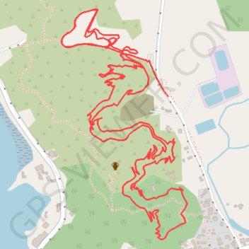
- Distance: 5.9 Km
- Elevation gain: 167 m
- Maximum elevation: 65 m
- Elevation loss: 174 m
- Minimum elevation: 8 m
- Moving time: 39 m 40 s
- Moving speed: 8.9 Km/h
- Maximum speed: 39.3 Km/h
- Total time: 58 m 51 s
- Global speed: 6.0 Km/h
Interactive trail map
Trail profile
- Distance: 5.9 Km
- Elevation gain: 167 m
- Maximum elevation: 65 m
- Elevation loss: 174 m
- Minimum elevation: 8 m
- Moving time: 39 m 40 s
- Moving speed: 8.9 Km/h
- Maximum speed: 39.3 Km/h
- Total time: 58 m 51 s
- Global speed: 6.0 Km/h
About this trail
Name: Coromandel Mountain Biking trail, distance, elevation, map, profile, GPS track
Coordinates: -36.76066 175.48732 -36.75359 175.49214