Cascade Falls Loop Trail in Patapsco Valley State Park
The Cascade Falls Loop Trail is an enjoyable and moderate hike known for its picturesque landscapes and water features. Along the route, hikers can admire several small waterfalls, including the stunning Cascade Falls itself, which is easily accessible and offers a tranquil pool at its base. The trail also meanders through scenic woodlands, providing opportunities to explore creeks and rocky terrain, with peaceful spots for resting. #Hiking #Loop #Waterfall #River #Forest #Nature
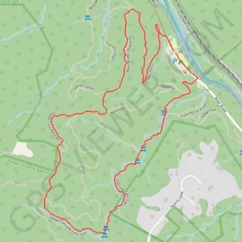
- Distance: 3.8 Km
- Elevation gain: 116 m
- Maximum elevation: 120 m
- Elevation loss: 116 m
- Minimum elevation: 23 m
- Moving time: 1 h 1 m
- Moving speed: 3.7 Km/h
- Maximum speed: 6.9 Km/h
- Total time: 1 h 3 m
- Global speed: 3.6 Km/h
Interactive trail map
Trail profile
- Distance: 3.8 Km
- Elevation gain: 116 m
- Maximum elevation: 120 m
- Elevation loss: 116 m
- Minimum elevation: 23 m
- Moving time: 1 h 1 m
- Moving speed: 3.7 Km/h
- Maximum speed: 6.9 Km/h
- Total time: 1 h 3 m
- Global speed: 3.6 Km/h
About this trail
Name: Cascade Falls Loop Trail in Patapsco Valley State Park trail, distance, elevation, map, profile, GPS track
Coordinates: 39.23457 -76.75818 39.24389 -76.74994
Other hiking, mountain biking, running and outdoor activity trails
Click on a trail to view its statistics, map and profile.
Patapsco Valley State Park - Orange Grove Area Loop
United States > Maryland > Howard County > Columbia
Distance: 11.5 Km • Elevation gain: 231 m • Maximum elevation: 117 m
Patapsco Valley State Park - Hilton Area Loop Hike
United States > Maryland > Baltimore County > Catonsville
Distance: 6.5 Km • Elevation gain: 182 m • Maximum elevation: 122 m
Cascade Falls Loop Trail in Patapsco Valley State Park
United States > Maryland > Howard County > Elkridge
Distance: 6.4 Km • Elevation gain: 124 m • Maximum elevation: 117 m
Patapsco Valley State Park Hilton Area
United States > Maryland > Baltimore County > Catonsville
Distance: 8.9 Km • Elevation gain: 240 m • Maximum elevation: 123 m
Patapsco Valley State Park Hilton Area Loop
United States > Maryland > Baltimore County > Catonsville
Distance: 7.0 Km • Elevation gain: 188 m • Maximum elevation: 123 m
Patapsco Valley State Park Hilton Area Loop
United States > Maryland > Baltimore County > Catonsville
Distance: 9.9 Km • Elevation gain: 251 m • Maximum elevation: 125 m
Patapsco Valley State Park Hilton Area Loop Hike
United States > Maryland > Baltimore County > Catonsville
Distance: 7.1 Km • Elevation gain: 181 m • Maximum elevation: 123 m
Patapsco River and Santee Branch Trail loop
United States > Maryland > Baltimore County > Catonsville
Distance: 9.0 Km • Elevation gain: 221 m • Maximum elevation: 123 m
Patapsco Valley State Park Hilton Area Loop
United States > Maryland > Howard County > Ilchester
Distance: 9.9 Km • Elevation gain: 273 m • Maximum elevation: 123 m
Patapsco Valley State Park Hilton Area
United States > Maryland > Baltimore County > Catonsville
Morning Loop Hike
Distance: 10.9 Km • Elevation gain: 234 m • Maximum elevation: 125 m
Patapsco Valley State Park
United States > Maryland > Baltimore County > Catonsville
Morning Loop Hike
Distance: 9.9 Km • Elevation gain: 320 m • Maximum elevation: 125 m
Morning Hike
United States > Maryland > Baltimore County > Catonsville
Distance: 9.6 Km • Elevation gain: 223 m • Maximum elevation: 123 m