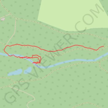
Forest path near Shimna River
- Distance: 0.7 Km
- Elevation gain: 10 m
- Maximum elevation: 45 m
- Elevation loss: 11 m
- Minimum elevation: 38 m
- Moving time: 11 m 5 s
- Moving speed: 3.9 Km/h
- Maximum speed: 6.1 Km/h
- Total time: 13 m 41 s
- Global speed: 3.2 Km/h
Interactive trail map
Trail profile
- Distance: 0.7 Km
- Elevation gain: 10 m
- Maximum elevation: 45 m
- Elevation loss: 11 m
- Minimum elevation: 38 m
- Moving time: 11 m 5 s
- Moving speed: 3.9 Km/h
- Maximum speed: 6.1 Km/h
- Total time: 13 m 41 s
- Global speed: 3.2 Km/h
About this trail
Name: Forest path near Shimna River trail, distance, elevation, map, profile, GPS track
Coordinates: 54.22129 -5.93339 54.22192 -5.92784
Other hiking, mountain biking, running and outdoor activity trails
Click on a trail to view its statistics, map and profile.
CTS-N.Irelandv1.1-Belfast-Titanic>Enniscrone-via antrim coast-209miles
United Kingdom > Northern Ireland > County Down > Belfast
Distance: 335.8 Km • Elevation gain: 3,985 m • Maximum elevation: 271 m