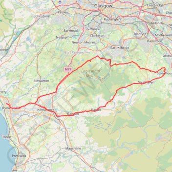
Irvine, Scotland to Stonehouse and back
Stonehouse, South Lanarkshire, Bike, Loop
- Distance: 111.8 Km
- Elevation gain: 1,118 m
- Maximum elevation: 302 m
- Elevation loss: 1,118 m
- Minimum elevation: 10 m
- Moving time: 5 h 58 m
- Moving speed: 18.7 Km/h
- Maximum speed: 45.5 Km/h
- Total time: 7 h 3 m
- Global speed: 15.8 Km/h
Interactive trail map
Trail profile
- Distance: 111.8 Km
- Elevation gain: 1,118 m
- Maximum elevation: 302 m
- Elevation loss: 1,118 m
- Minimum elevation: 10 m
- Moving time: 5 h 58 m
- Moving speed: 18.7 Km/h
- Maximum speed: 45.5 Km/h
- Total time: 7 h 3 m
- Global speed: 15.8 Km/h
About this trail
Name: Irvine, Scotland to Stonehouse and back trail, distance, elevation, map, profile, GPS track
Start: 66, Oaklands Avenue, Irvine, North Ayrshire, Scotland, KA12 0UE, United Kingdom (55.62439 -4.66407)
End: 64, Oaklands Avenue, Irvine, North Ayrshire, Scotland, KA12 0SE, United Kingdom (55.62424 -4.66368)
Coordinates: 55.59356 -4.66407 55.74001 -3.98137
Other hiking, mountain biking, running and outdoor activity trails
Click on a trail to view its statistics, map and profile.
Irvine, Scotland to Stevenston and back
United Kingdom > Scotland > North Ayrshire > Irvine
Morning Bike Ride
Distance: 18.9 Km • Elevation gain: 69 m • Maximum elevation: 28 m
Irvine, Scotland to Troon and back
United Kingdom > Scotland > North Ayrshire > Irvine
Evening Bike Ride
Distance: 33.8 Km • Elevation gain: 383 m • Maximum elevation: 128 m
Irvine, Scotland to Largs and back
United Kingdom > Scotland > North Ayrshire > Irvine
Morning Bike Ride
Distance: 66.9 Km • Elevation gain: 324 m • Maximum elevation: 35 m
Irvine, Scotland to Eglinton Country Park and back
United Kingdom > Scotland > North Ayrshire > Irvine
Loop Bike
Distance: 13.7 Km • Elevation gain: 67 m • Maximum elevation: 32 m
Shewalton Wood Wildlife Reserve & Barassie Beach
United Kingdom > Scotland > North Ayrshire > Irvine
Bike
Distance: 26.1 Km • Elevation gain: 92 m • Maximum elevation: 18 m
Irvine, Scotland to Kilmarnock and back
United Kingdom > Scotland > North Ayrshire > Irvine
Bike
Distance: 32.1 Km • Elevation gain: 192 m • Maximum elevation: 66 m
Irvine, Scotland to Troon and back
United Kingdom > Scotland > North Ayrshire > Irvine
Afternoon Loop Bike Ride
Distance: 33.7 Km • Elevation gain: 313 m • Maximum elevation: 129 m
Irvine, Scotland to West Kilbride and back
United Kingdom > Scotland > North Ayrshire > Irvine
Afternoon Bike Ride
Distance: 40.2 Km • Elevation gain: 283 m • Maximum elevation: 101 m
Irvine, Scotland to Greenan Castle and back
United Kingdom > Scotland > North Ayrshire > Irvine
Bike
Distance: 59.4 Km • Elevation gain: 237 m • Maximum elevation: 27 m
Irvine, Scotland to Barassie Beach and back
United Kingdom > Scotland > North Ayrshire > Irvine
Bike
Distance: 21.7 Km • Elevation gain: 86 m • Maximum elevation: 15 m
Irvine, Scotland to Stevenston and back
United Kingdom > Scotland > North Ayrshire > Irvine
Afternoon Bike Ride
Distance: 18.8 Km • Elevation gain: 71 m • Maximum elevation: 28 m
Irvine, Scotland to Kilmarnock and back
United Kingdom > Scotland > North Ayrshire > Irvine
Afternoon Bike Ride
Distance: 34.2 Km • Elevation gain: 217 m • Maximum elevation: 91 m
Irvine, Scotland to Kilmarnock and back
United Kingdom > Scotland > North Ayrshire > Irvine
Evening Bike Ride
Distance: 42.0 Km • Elevation gain: 259 m • Maximum elevation: 92 m
Irvine, Scotland to Stevenston and back
United Kingdom > Scotland > North Ayrshire > Irvine
Morning Bike Ride
Distance: 19.0 Km • Elevation gain: 75 m • Maximum elevation: 29 m
Irvine, Scotland to Kilmarnock and back
United Kingdom > Scotland > North Ayrshire > Irvine
Morning Bike Ride
Distance: 27.2 Km • Elevation gain: 147 m • Maximum elevation: 57 m
Afternoon at the Beach, Irvine, Scotland
United Kingdom > Scotland > North Ayrshire > Irvine
Distance: 7.2 Km • Elevation gain: 32 m • Maximum elevation: 16 m
Irvine, Scotland to Ardrossan and back
United Kingdom > Scotland > North Ayrshire > Irvine
Bike
Distance: 31.2 Km • Elevation gain: 115 m • Maximum elevation: 22 m
Irvine, Scotland to Dalry and back
United Kingdom > Scotland > North Ayrshire > Irvine
Evening Loop Bike Ride
Distance: 28.8 Km • Elevation gain: 274 m • Maximum elevation: 106 m
Irvine, Scotland to Dalry and back
United Kingdom > Scotland > North Ayrshire > Irvine
Bike
Distance: 26.7 Km • Elevation gain: 254 m • Maximum elevation: 70 m
Irvine, Scotland to Kilwinning
United Kingdom > Scotland > North Ayrshire > Irvine
Afternoon Bike Ride
Distance: 5.3 Km • Elevation gain: 20 m • Maximum elevation: 22 m
Irvine, Scotland to Ayr and back
United Kingdom > Scotland > North Ayrshire > Irvine
Bike
Distance: 52.9 Km • Elevation gain: 181 m • Maximum elevation: 16 m
Irvine, Scotland to Ayr and back
United Kingdom > Scotland > North Ayrshire > Irvine
Bike
Distance: 46.1 Km • Elevation gain: 135 m • Maximum elevation: 16 m
Shewalton Sandpits Wildlife Reserve (Walk)
United Kingdom > Scotland > North Ayrshire > Irvine
Irvine, Scotland
Distance: 1.6 Km • Elevation gain: 6 m • Maximum elevation: 11 m
Sunset at the Beach
United Kingdom > Scotland > North Ayrshire > Irvine
Bike
Distance: 8.2 Km • Elevation gain: 28 m • Maximum elevation: 15 m
Evening Gravel Scouting
United Kingdom > Scotland > North Ayrshire > Irvine
Distance: 22.7 Km • Elevation gain: 81 m • Maximum elevation: 19 m
Afternoon at the Beach
United Kingdom > Scotland > North Ayrshire > Irvine
Distance: 7.6 Km • Elevation gain: 35 m • Maximum elevation: 16 m
Irvine, Scotland
United Kingdom > Scotland > North Ayrshire > Irvine
Evening Loop Bike Ride
Distance: 34.3 Km • Elevation gain: 89 m • Maximum elevation: 15 m
Irvine, Scotland
United Kingdom > Scotland > North Ayrshire > Irvine
Afternoon Loop Walk
Distance: 6.2 Km • Elevation gain: 27 m • Maximum elevation: 16 m
Irvine Loop Bike
United Kingdom > Scotland > North Ayrshire > Irvine
Afternoon Ride
Distance: 14.5 Km • Elevation gain: 45 m • Maximum elevation: 16 m
Whitelee Wind Farm, Scotland
United Kingdom > Scotland > East Renfrewshire > Eaglesham
Walk
Distance: 1.0 Km • Elevation gain: 12 m • Maximum elevation: 295 m
Escort to Troon
United Kingdom > Scotland > North Ayrshire > Irvine
Bike
Distance: 34.9 Km • Elevation gain: 125 m • Maximum elevation: 19 m
Irvine Beach
United Kingdom > Scotland > North Ayrshire > Irvine
Bike
Distance: 8.5 Km • Elevation gain: 33 m • Maximum elevation: 16 m
Beach Gravel
United Kingdom > Scotland > North Ayrshire > Irvine
Distance: 12.2 Km • Elevation gain: 56 m • Maximum elevation: 16 m
Kilmarnock, Scotland
United Kingdom > Scotland > East Ayrshire > Kilmarnock
Afternoon Walk
Distance: 2.0 Km • Elevation gain: 7 m • Maximum elevation: 35 m
Dean Castle
United Kingdom > Scotland > East Ayrshire > Kilmarnock
Distance: 2.2 Km • Elevation gain: 34 m • Maximum elevation: 66 m
Irvine, Scotland
United Kingdom > Scotland > North Ayrshire > Irvine
Afternoon Walk
Distance: 1.5 Km • Elevation gain: 9 m • Maximum elevation: 16 m