Dan Stiller Reserve Trail Run
- Distance: 11.7 Km
- Elevation gain: 114 m
- Maximum elevation: 48 m
- Elevation loss: 114 m
- Minimum elevation: 20 m
- Moving time: 1 h 19 m
- Moving speed: 8.8 Km/h
- Maximum speed: 13.4 Km/h
- Total time: 1 h 19 m
- Global speed: 8.8 Km/h
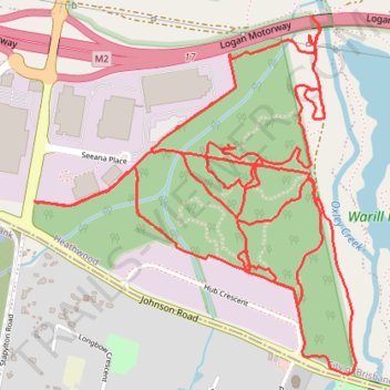
Interactive trail map
Trail profile
- Distance: 11.7 Km
- Elevation gain: 114 m
- Maximum elevation: 48 m
- Elevation loss: 114 m
- Minimum elevation: 20 m
- Moving time: 1 h 19 m
- Moving speed: 8.8 Km/h
- Maximum speed: 13.4 Km/h
- Total time: 1 h 19 m
- Global speed: 8.8 Km/h
About this trail
Name: Dan Stiller Reserve Trail Run trail, distance, elevation, map, profile, GPS track
Start: Johnson Road, Forestdale, Greater Brisbane, Queensland, 4110, Australia (-27.65457 152.99911)
End: Johnson Road, Forestdale, Greater Brisbane, Queensland, 4110, Australia (-27.65458 152.99908)
Coordinates: -27.65464 152.98454 -27.63995 152.99935
Topography: Queensland topographic map, elevation, terrain
Other hiking, mountain biking, running and outdoor activity trails
Click on a trail to view its statistics, map and profile.
Gravel loop ride via Karawatha
Australia > Queensland > City of Brisbane
Distance: 60.4 Km • Elevation gain: 620 m • Maximum elevation: 110 m