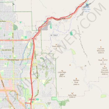
Ride up to Bridal Veil Falls
- Distance: 24.0 Km
- Elevation gain: 252 m
- Maximum elevation: 1,566 m
- Elevation loss: 244 m
- Minimum elevation: 1,412 m
Interactive trail map
Trail profile
- Distance: 24.0 Km
- Elevation gain: 252 m
- Maximum elevation: 1,566 m
- Elevation loss: 244 m
- Minimum elevation: 1,412 m
About this trail
Name: Ride up to Bridal Veil Falls trail, distance, elevation, map, profile, GPS track
Coordinates: 40.26216 -111.66434 40.33966 -111.60520
Other hiking, mountain biking, running and outdoor activity trails
Click on a trail to view its statistics, map and profile.
Right up to the Linden Temple and by Utah Lake
United States > Utah > Utah County > Provo > Pleasant View
Bonk ride to Lindon and by Utah Lake lake, lindon, utah, bike, paved
Distance: 37.0 Km • Elevation gain: 223 m • Maximum elevation: 1,487 m