Make a donation
Gear up for your next adventure:
As an Amazon Associate, this site earns from qualifying purchases at no extra cost to you.
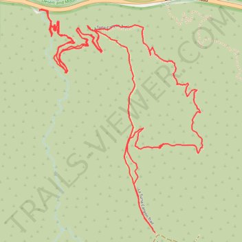
Old La Tuna Canyon hike
- Distance: 6.3 Km
- Elevation gain: 419 m
- Maximum elevation: 687 m
- Elevation loss: 419 m
- Minimum elevation: 407 m
- Moving time: 2 h 12 m
- Moving speed: 2.8 Km/h
- Maximum speed: 6.1 Km/h
- Total time: 2 h 52 m
- Global speed: 2.2 Km/h
Interactive trail map
Make a donation
Gear up for your next adventure:
As an Amazon Associate, this site earns from qualifying purchases at no extra cost to you.
Trail profile
- Distance: 6.3 Km
- Elevation gain: 419 m
- Maximum elevation: 687 m
- Elevation loss: 419 m
- Minimum elevation: 407 m
- Moving time: 2 h 12 m
- Moving speed: 2.8 Km/h
- Maximum speed: 6.1 Km/h
- Total time: 2 h 52 m
- Global speed: 2.2 Km/h
Make a donation
Gear up for your next adventure:
As an Amazon Associate, this site earns from qualifying purchases at no extra cost to you.
About this trail
Name: Old La Tuna Canyon hike trail, distance, elevation, map, profile, GPS track
Coordinates: 34.22405 -118.31177 34.23321 -118.30371
Make a donation
Gear up for your next adventure:
As an Amazon Associate, this site earns from qualifying purchases at no extra cost to you.
Other hiking, mountain biking, running and outdoor activity trails
Click on a trail to view its statistics, map and profile.
Verdugo Mountains Full Ridge
United States > California > Los Angeles County > Los Angeles
Hike on the Verdugo Mountains via Village Avenue Trail, La Tuna Peak, Chandler Mtrwy, Boy Scout Camp, Verdugo Motorway, Verdugo Crest Trail, Tree of Life, Wildhos Saddle, Verdugo Peak, Mesa Lila Road, Mount Thom and Las Flores Motorway. #Hiking #Mountain #Nature #Forest #Park
Distance: 23.3 Km • Elevation gain: 1,174 m • Maximum elevation: 946 m