Make a donation
Gear up for your next adventure:
As an Amazon Associate, this site earns from qualifying purchases at no extra cost to you.
Ouzel Falls, Calypso Cascades and Copeland Falls
Via Wild Basin Trail in Rocky Mountain National Park #Hiking #Waterfall #River #Forest #Mountain
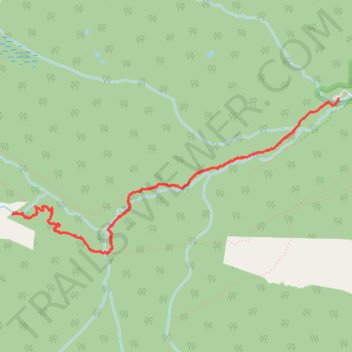
- Distance: 9.0 Km
- Elevation gain: 336 m
- Maximum elevation: 2,886 m
- Elevation loss: 335 m
- Minimum elevation: 2,592 m
- Moving time: 2 h 27 m
- Moving speed: 3.6 Km/h
- Maximum speed: 5.9 Km/h
- Total time: 3 h 35 m
- Global speed: 2.5 Km/h
Interactive trail map
Make a donation
Gear up for your next adventure:
As an Amazon Associate, this site earns from qualifying purchases at no extra cost to you.
Trail profile
- Distance: 9.0 Km
- Elevation gain: 336 m
- Maximum elevation: 2,886 m
- Elevation loss: 335 m
- Minimum elevation: 2,592 m
- Moving time: 2 h 27 m
- Moving speed: 3.6 Km/h
- Maximum speed: 5.9 Km/h
- Total time: 3 h 35 m
- Global speed: 2.5 Km/h
Make a donation
Gear up for your next adventure:
As an Amazon Associate, this site earns from qualifying purchases at no extra cost to you.
About this trail
Name: Ouzel Falls, Calypso Cascades and Copeland Falls trail, distance, elevation, map, profile, GPS track
Start: County Highway 115, Boulder County, Colorado, 80510, United States (40.20788 -105.56645)
End: County Highway 115, Boulder County, Colorado, 80510, United States (40.20790 -105.56645)
Coordinates: 40.19548 -105.60051 40.20790 -105.56645
Make a donation
Gear up for your next adventure:
As an Amazon Associate, this site earns from qualifying purchases at no extra cost to you.
Other hiking, mountain biking, running and outdoor activity trails
Click on a trail to view its statistics, map and profile.
Ouzel Falls, Calypso Cascades and Copeland Falls via Wild Basin Trail
United States > Colorado > Boulder County
The Wild Basin Trail in Rocky Mountain National Park offers hikers a scenic journey through lush forests alongside the melodious North St. Vrain Creek. Early in the hike, visitors encounter the tranquil beauty of Copeland Falls, followed by the impressive Calypso Cascades, where water tumbles gracefully over a…
Distance: 9.2 Km • Elevation gain: 337 m • Maximum elevation: 2,868 m