A century solo ride - clockwise cycling the Bogd mountain #PowerMap #StatMaps
- Distance: 105.9 Km
- Elevation gain: 1,046 m
- Maximum elevation: 1,671 m
- Elevation loss: 1,046 m
- Minimum elevation: 1,278 m
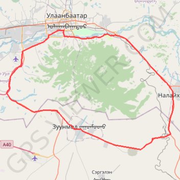
Interactive trail map
Trail profile
- Distance: 105.9 Km
- Elevation gain: 1,046 m
- Maximum elevation: 1,671 m
- Elevation loss: 1,046 m
- Minimum elevation: 1,278 m
About this trail
Name: A century solo ride - clockwise cycling the Bogd mountain #PowerMap #StatMaps trail, distance, elevation, map, profile, GPS track
Start: Bogd Javzandamba street, Khan-Uul, Ulaanbaatar, 17040, Mongolia (47.89619 106.90901)
End: Fides Tower, Унадаг дугуйн зам, Khan-Uul, Ulaanbaatar, 17012, Mongolia (47.89865 106.90963)
Coordinates: 47.66168 106.74006 47.89923 107.23335
Other hiking, mountain biking, running and outdoor activity trails
Click on a trail to view its statistics, map and profile.
UDA 7 davaa challenge
Distance: 135.2 Km • Elevation gain: 2,583 m • Maximum elevation: 2,015 m
A century solo ride - clockwise cycling the Bogd mountain #PowerMap #StatMaps
Distance: 105.9 Km • Elevation gain: 1,046 m • Maximum elevation: 1,671 m