Make a donation
Gear up for your next adventure:
As an Amazon Associate, this site earns from qualifying purchases at no extra cost to you.
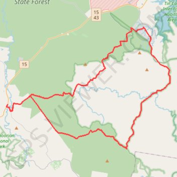
Goomboorian - Cooloola Cove
Interactive trail map
Make a donation
Gear up for your next adventure:
As an Amazon Associate, this site earns from qualifying purchases at no extra cost to you.
Trail profile
- Distance: 82.8 Km
- Elevation gain: 923 m
- Maximum elevation: 102 m
- Elevation loss: 923 m
- Minimum elevation: 5 m
Make a donation
Gear up for your next adventure:
As an Amazon Associate, this site earns from qualifying purchases at no extra cost to you.
About this trail
Name: Goomboorian - Cooloola Cove trail, distance, elevation, map, profile, GPS track
Coordinates: -26.13399 152.78037 -25.96972 153.02644
Topography: Queensland topographic map, elevation, terrain
Make a donation
Gear up for your next adventure:
As an Amazon Associate, this site earns from qualifying purchases at no extra cost to you.
Other hiking, mountain biking, running and outdoor activity trails
Click on a trail to view its statistics, map and profile.
Great Sandy National Park - Toolara Forest
#MTB #Loop #GreatSandy #Toolara
Distance: 88.4 Km • Elevation gain: 927 m • Maximum elevation: 102 m
Harrys Hut - Neebs Waterhole
Great Sandy National Park. #MTB #Loop #GreatSandy
Distance: 50.3 Km • Elevation gain: 476 m • Maximum elevation: 95 m