Import a GPX file

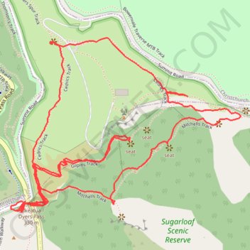
Sugarloaf Scenic Reserve Loop

Loop hike in the Sugarloaf Scenic Reserve via Cedrics Track, Gilpins Track and Mitchells Track. #Hiking #Loop #Nature #Forest #Mountain

  • Distance: 4.9 Km
  • Elevation gain: 321 m
  • Maximum elevation: 456 m
  • Elevation loss: 312 m
  • Minimum elevation: 329 m

Interactive trail map

Trail profile

  • Distance: 4.9 Km
  • Elevation gain: 321 m
  • Maximum elevation: 456 m
  • Elevation loss: 312 m
  • Minimum elevation: 329 m

About this trail

Other hiking, mountain biking, running and outdoor activity trails

Click on a trail to view its statistics, map and profile.

Tour Te Waipounamu

New Zealand > Tasman > Tasman District > Port Pūponga

Bikepacking race through the South Island of New Zealand. #Bike #Race #Island #Sea #Pacific #Ocean #Nature #Mountain #Forest #Countryside

Distance: 1,321.0 Km • Elevation gain: 23,362 m • Maximum elevation: 1,946 m

Halswell River

New Zealand > Canterbury > Christchurch City > Banks Peninsula Community

Distance: 68.9 Km • Elevation gain: 320 m • Maximum elevation: 40 m

Gear up for your next adventure:

🪫Rechargeable Headlamps - USB rechargeable headlamps
🥾Hiking Boots - Durable hiking boots for trails and rough terrain
🧼Clip-on Hand Sanitizer - Maintain hygiene when water for washing is scarce
🐍Australian Snake Bite Kits - Specific pressure immobilization bandages for Australian venomous snakes
🚴Cycling Backpacks - Backpacks for cyclists

As an Amazon Associate, this site earns from qualifying purchases at no extra cost to you.